#+title: Adding details to a sketched terrain
#+date: <2017-07-24 Mon>
#+begin_export html
Note: the /x/ series of posts on my site are mostly unpolished mini posts. I'm trying out a few different ideas for procedural map generation; this is one of them.
#+end_export
The past few mini projects were:
- [[../1723-procedural-river-growing/][Generating rivers from coastlines]]
- [[../1724-elevation-from-rivers/][Generating elevation from rivers, part 1]]
- [[../1725-procedural-elevation/][Generating elevation from rivers, part 2]]
- [[../1728-elevation-control/][Sketching coastlines and mountain ranges]]
This week I'm going to glue these together (in a hacky way for now): sketch coastlines and mountain ranges, and see what rivers and elevation are generated.
The page may be a little flaky. I'm including the javascript from two separate projects and hacking them to work together. I'll fix it up later but for now I just wanted to see if it worked at all.
* Sketch
:PROPERTIES:
:CUSTOM_ID: sketch
:END:
Sketch @@html:⯀@@mountain ridges or @@html:⯀@@coastlines: @@html: @@
#+begin_export html
Noise:
#+end_export
The rivers will /mostly/ follow the guidelines, but I have some randomness in there to allow rivers to cut through mountain ridges occasionally. That parameter will need to be tweaked eventually.
#+begin_export html
#+end_export
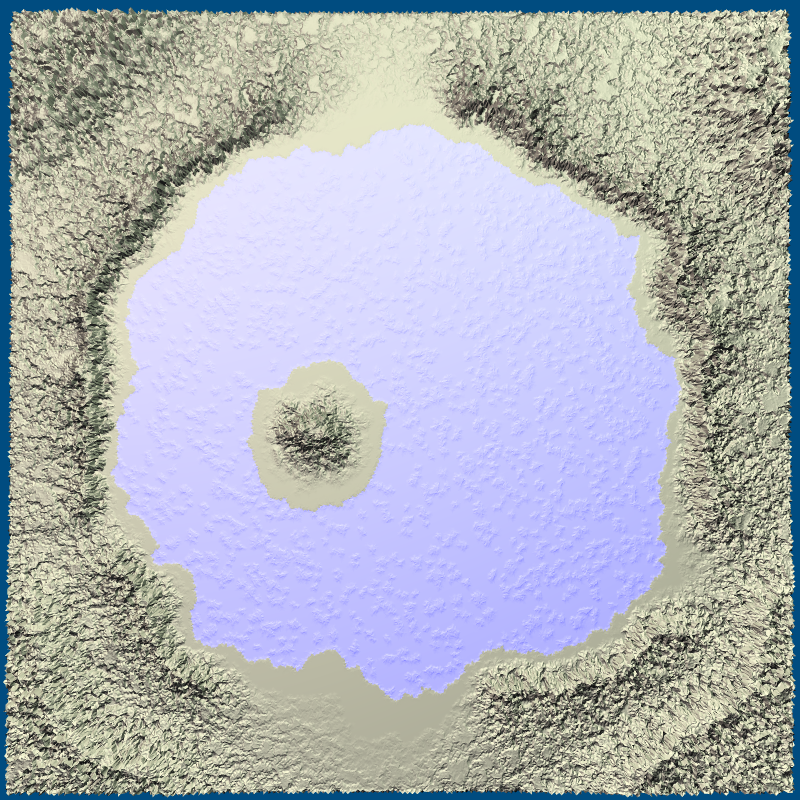
Bonus feature: To make an interior lake, draw the lake as a coastline. By default the interior will be land. Draw inside the coastline with @@html: @@ to make it a lake instead. Some of the algorithms work on non-island maps too. If you @@html: @@ of the map you can make a crater lake.
* Export to elevation image
:PROPERTIES:
:CUSTOM_ID: export-to-elevation-image
:END:
The idea behind sketching was that you're drawing /lines/ which are then mapped onto a /mesh/. If I keep the original lines, I can map them onto a higher resolution mesh. For this project, it was quicker to draw the elevations to a bitmap and then build a new mesh from the bitmap. Here's the bitmap:
#+begin_export html
Sharp:
#+end_export
The parameter controls the elevation exponent, which I often use to sharpen mountain peaks. The bitmap is used for the next section.
* Generate detailed elevation
:PROPERTIES:
:CUSTOM_ID: generate-detailed-elevation
:END:
From [[../1725-procedural-elevation/][two blog posts ago]], I came up with some algorithms to carve canyons and ravines into the terrain. (This renderer may not work across platforms… still need to look into that)
#+begin_export html
#+end_export
Try changing the sharpness slider above and re-rendering.
It looks neat but I don't know if we're going to use it for our game.
(Update: the game was cancelled, but I was able to improve the rendering significantly, and some of this ended up in [[https://www.redblobgames.com/maps/mapgen4/][mapgen4]] a year later.)
* Next steps
:PROPERTIES:
:CUSTOM_ID: next-steps
:END:
This week was about a quick hack to combine the last few mini projects to see if everything would work together. It didn't at first but I found many bugs and fixed them, and now it seems to work reasonably.
Now that I know these steps work together, the next step is biomes.
Also take a look at [[http://entropicparticles.com/procedure-for-rivers-and-lakes/][this page]], which has a river algorithm that does a lot more than mine does: lakes, erosion, deposition, river deltas, water tables, snow, surface tension, capillary action. Cool! I didn't try those algorithms; our game doesn't need them.
#+begin_export html
Created 18 Jul 2017 with Emacs org-mode (source of this page); code uses Delaunator, glmatrix, and regl.js
Last modified: 18 Aug 2022
#+end_export